
water levels
Understanding Seasonal Fluctuations
Water levels are impacted by our dam and by Mother Nature.
The water level on Koshlong Lake is controlled by Parks Canada via a Trent-Severn Waterway (TSW) dam located on the southwest end of the lake, which flows into the Burnt River, and from there into the TSW. Parks Canada uses Koshlong as a reservoir, lowering the lake in summer to maintain sufficient draught for the main navigation channel on the canal portion of the TSW. During the control period, the water level in Koshlong varies between its highest in April/May to its lowest in October. The average change in water level between the high and low water marks is approximately 1 metre.
Parks Canada also provides a drawdown forecast for all lakes in the Trent-Severn waterway. Parks Canada provides up-to-date reports of water levels on Koshlong in their Water Management Infonet section. The following chart is an example: the orange line depicts the multi-year average water level on Koshlong Lake since 1988; the red line (maximum) and green line (minimum) shows the potential variability of water levels recorded over the same period. The blue line indicates current water levels -- here, you can see that the water level in Koshlong was above average in the spring of 2026 due to late winter snow and rain. In 2025 spring levels were also high, but by the end of July fell below average due to lack of rainfall through the summer, and very hot conditions causing excess evaporation. Some of these fluctuations may be attributed to altered weather patterns resulting from climate change.


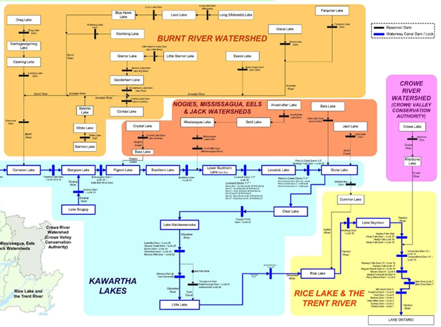
The chart below shows the interconnectivity of the lakes and rivers in the TWS. Koshlong feeds into the system via the Burnt River watershed, depicted in the orange area at the top of the chart.
For more information about water levels on the TSW, visit the Coalition for Equitable Water Flow.
- Home
- Environment
- Monitoring & Mitigation
- Water Levels
Thanks to KLA member Rob Horsburgh for his photograph of Wallace Island used as the background photo throughout this site